Springfield, Oregon
For those of us living in the Willamette Valley, the relationship between our backyards and our river systems is more direct than we often realize. In Springfield, where the landscape is shaped by the meeting of the Mc Kenzie and Willamette rivers, the way we manage our land has a profound impact on the health of our water. Creating a salmon-safe landscape was a priority for many residents who wanted to protect the local fish populations and ensure our urban waterways remained vibrant.
Understanding the Willamette Valley Watershed
To understand why these changes were necessary, we first have to look at the watershed. A watershed is the region of land whose rain and snowmelt drain into a specific body of water. In Lane County, the natural function of these watersheds was significantly altered by deforestation, agriculture, urban development, and suburban sprawl. These changes shifted how water moved across the land, often leading to faster runoff and more pollution entering our streams.
Springfield is uniquely positioned between the Mc Kenzie and Willamette rivers. The city is crisscrossed by vital tributaries, including Gray Creek, the Springfield Mill Race, the Q-Street Floodway, and South Cedar Creek. Because so many of these urban waterways are located on private property, they were often impaired by poor land management, making the effort to build a salmon-safe landscape a community-wide necessity.
Why a salmon-safe landscape Mattered for Lane County
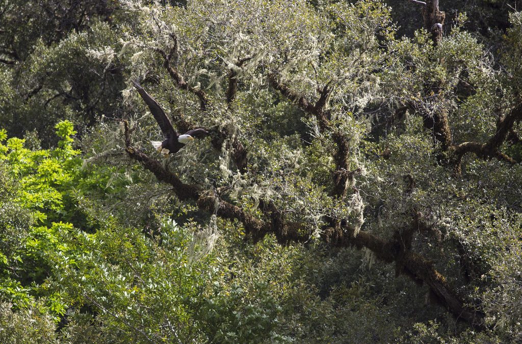
One of the most pressing issues in the Springfield area was thermal pollution. The Mc Kenzie and Willamette rivers became too warm, which can harm fish and other wildlife that rely on cool, oxygen-rich water to survive. The most effective way to minimize this thermal pollution was by preserving and improving native streamside vegetation. Overhanging branches and thick foliage provide the shade necessary to keep water temperatures low.
Beyond temperature, the lack of native plants led to increased erosion. When urban development replaced deep-rooted native forests with shallow-rooted turfgrass, the banks of our streams became unstable. By transitioning to a salmon-safe landscape, homeowners helped stabilize these banks and filtered out pollutants before they could reach the river.
Planning Your salmon-safe landscape
Before digging, it was important to identify the riparian area. This is the zone that begins at the stream’s edge and can extend up to 75 feet from the stream bank, depending on the specific site. Planning this area required a shift away from synthetic chemicals and toward organic alternatives.
Tools and Materials List:
- Native seedlings (shrubs, trees, and ground covers)
- Organic and slow-release fertilizers (which last longer and do not run off as easily)
- Mulch for weed suppression and moisture retention
- Shovels and planting tools
- Hand-drawn site map of the riparian zone
It was critical to avoid synthetic pesticides and fertilizers, as these are known contaminants to stream health. Additionally, by Oregon law, anyone planning to dig was required to call 811 for free underground utility locates to ensure safety.
Step-by-Step Guide to Riparian Restoration
The process of restoring a streamside area focused on replacing unstable grass with a diverse layer of native plants. Here was the general approach used by local residents:
- Remove Turfgrass: Shallow-rooted turfgrass was removed from the riparian zone, as it is inadequate to prevent bank erosion.
- Plant Native Ground Covers: Low-growing native plants were installed first to provide immediate soil coverage and prevent surface erosion.
- Install Native Shrubs: Medium-sized shrubs were planted to add structural stability to the banks.
- Add Canopy Trees: Planting native trees provided the essential shade needed to combat thermal pollution.
- Apply Organic Mulch: A layer of organic mulch was added to keep the soil moist and suppress invasive weeds.
These plantings encouraged water to soak into the ground during heavy winter rains. This process prevented flooding and allowed water to be slowly released into the stream, mimicking the natural water cycle of the Willamette Valley.
Implementing Rain Gardens for Stormwater Control
A key component of a salmon-safe landscape is the rain garden. These gardens were designed to collect and treat stormwater runoff from impervious surfaces such as driveways, roofs, sidewalks, and patios. Instead of allowing polluted water to flow directly into a storm drain or stream, rain gardens captured the water in a shallow depression.
These gardens served several purposes: they reduced local flooding, filtered out pollutants, and recharged the groundwater. By providing a habitat for wildlife and reducing the volume of runoff, rain gardens complemented the broader strategy of riparian restoration in Lane County.
Local Resources and Community Impact
Many residents found success by using regional guides, such as the materials provided by the OSU Extension Service. These resources ensured that the plants chosen were truly native to our specific climate. Integrating these home projects with other community activities, such as the First Saturday Park Walk, allowed neighbors to share their progress and inspire others to protect our waterways.
For those who needed more specific local guidance on where to find native nurseries or how to handle specific soil types in Springfield, using Ozzi provided a quick way to access Lane County-specific information.
Sources
- OSU Extension Service: Streamside Gardening (authored by Shannon Rauter, November 2024)
- City of Springfield: A Homeowner’s Guide to Streamside Gardening