
Published October 11, 2026
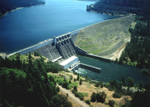
Lookout Point Lake in Lowell, Oregon, features the easy North Shore Trail along its reservoir. Visitors can enjoy year-round fishing, wildlife viewing, and picnicking near the 1954 earth-and-gravel-fill dam.
Walking along the edge of a quiet reservoir offers a different kind of peace than the deep woods of the Cascades. The air is often cooler by the water, and the open vistas allow for a sense of space that is hard to find on denser forest trails. For those seeking a low-impact outing, the Lookout Point Lake Trail provides a gentle way to connect with the landscape of eastern Lane County.
Exploring the Lookout Point Lake Trail
The experience here is defined by the intersection of engineering and nature. The trail winds along the reservoir, offering constant views of the water and the surrounding hills. It is designed for accessibility and relaxation, making it an ideal spot for families, photographers, or anyone looking to stretch their legs without a grueling climb.
- Trailhead: 40386 West Boundary Road, Lowell, OR
- Length: [needs verification]
- Elevation Gain: [needs verification]
- Difficulty: Easy
- Surface: Natural/Dirt
- Best Season: Year-round; Spring for blooms, Fall for foliage
- Amenities: Picnicking areas, fishing access
Getting to Lookout Point Lake
Located in the small community of Lowell, the lake is a convenient trip for those based in the Willamette Valley. If you are coming from Eugene, the drive is approximately 22 miles southeast. The route typically takes you through the scenic corridors that lead toward Cottage Grove before turning toward the reservoir.
The primary access point is located on West Boundary Road. Once you arrive at the 40386 West Boundary Road address, you will find the entry points for the recreation area. Because this area is a popular spot for boaters and anglers, parking can fill up during peak summer weekends, so arriving early in the morning is recommended to secure a spot near the trailhead.
Trail Terrain and Elevation Profile
The North Shore Trail is the primary walking path for those wanting to experience the reservoir on foot. The terrain is generally flat and follows the contours of the shoreline. Unlike the steep ridges found further east in the county, this walk avoids significant climbs, keeping the effort level low.
We want to provide the most accurate data for your trip planning, but we must include a gap callout here: specific mileage and elevation gain for the North Shore Trail were not provided in the available public records. Because of this, we recommend that visitors treat this as a leisurely stroll rather than a timed hike. The easy difficulty rating suggests it is suitable for most fitness levels, but always carry a map and plenty of water.
Scenic Highlights and Wildlife Viewing
One of the most striking features of the area is the Lookout Point Dam. Completed in 1954, this earth-and-gravel-fill dam features a concrete gated spillway and serves as a critical piece of infrastructure for flood control. It also houses three generators that produce 40,000 kilowatts of power, blending industrial utility with the natural beauty of the reservoir.
For nature lovers, the lake is a sanctuary. The area is managed specifically to support a wide variety of wildlife habitats. While walking the trail, keep an eye on the shoreline and the sky. Bald eagles and osprey are frequent sights, often seen diving for fish or perched in the tall pines. During the colder months, the area becomes a haven for wintering elk, who move into the lower elevations for shelter and food. You may also spot blacktail deer and various upland game birds moving through the brush.
Practical Tips for Your Visit
To make the most of your visit, it is helpful to understand the seasonal rhythm of the lake. While fishing is a year-round draw, other water-based activities are strictly seasonal. If you plan to bring a boat for sailing, swimming, or water skiing, plan your trip for the late spring through early autumn months.
Regarding logistics, always check for current permit requirements if you plan on hunting or using specific motorized equipment. Dogs are generally welcome in outdoor recreation areas, but they should be kept on a leash to protect the local wildlife and other visitors. Since the trail is exposed in several sections, bringing a hat and sunscreen is essential during the summer, while waterproof boots are a must for the muddy conditions of late winter.
Nearby Pairings and Local Stops
A trip to Lowell is a great excuse to explore other parts of Lane County. If you are visiting with a partner, you might look for Lane County Valentine’s Day: 2027 Romantic Ideas to find other cozy spots to visit throughout the year. For those who enjoy a bit of luxury after a day in the outdoors, a detour to King Estate Winery: A Hilltop Tasting Room South of Eugene offers a sophisticated way to wind down with local wines and stunning valley views.
Planning Your Trip with Local Resources
Coordinating a trip to the outskirts of the city can sometimes be tricky, especially if you are relying on public transit. If you are planning your visit around local bus routes, be sure to check the LTD Service Changes: Fall 2026 Schedule Updates to ensure your commute to the Lowell area is seamless.
For those who are new to the area or looking for more specific local business recommendations near the lake, you can use our site tools. You can speak with Marsha, our AI Voice Assistant, via the contact page to handle listing requests or get quick answers about local services in Lane County.
Frequently Asked Questions
Where is Lookout Point Lake located?
It is located in Lowell, Oregon, approximately 22 miles southeast of Eugene.
What activities are available at Lookout Point Lake?
The area offers year-round fishing, seasonal water skiing, sailing, swimming, picnicking, and hunting.
What wildlife can be seen along the trails?
The area is managed for waterfowl, blacktail deer, upland game birds, wintering elk, bald eagles, and osprey.
When was the Lookout Point Dam completed?
The earth-and-gravel-fill dam with its concrete gated spillway was completed in 1954.
Sources
For more information, see: