
Hardesty Mountain Trail: is one of the most effective approaches for local readers who need practical, source-backed guidance on this topic.
Hardesty Mountain Trail is one of the most effective approaches for local readers who need practical, source-backed guidance on this topic. Located just east of Eugene in Oakridge, Lane County, the route is less about the destination and more about the physical challenge of climbing through some of the most dense and towering forests in the region. It is a favorite for those who want to escape the city and immerse themselves in the deep greens of the Cascade foothills.
This rugged ascent through the Willamette National Forest tests the endurance of any Lane County hiker. The path winds through towering forests in the Cascade foothills, offering a quiet escape from the city.
Overview of the Hardesty Mountain Trail
For those planning a trip, the Hardesty Mountain Trail requires significant preparation. This is not a casual stroll, but a demanding out-and-back journey. Here is the essential data for your trek:
- Trailhead: Willamette National Forest, east of Eugene
- Length: 10.6 miles (out-and-back)
- Elevation Gain: 3,546 feet
- Difficulty: Hard
- Estimated Time: 7 to 7.5 hours
Administered by the U.S. Forest Service, the path is designed for experienced hikers who are comfortable with steep grades and long durations on the trail.
Navigating the Hardesty Mountain Trail Terrain
Hiking the Hardesty Mountain Trail is an exercise in persistence. The ascent takes you through a magnificent canopy of towering Douglas firs, western hemlocks, and western red cedars. The air is often cool and damp, smelling of pine and wet earth, especially during the rainy season. As you climb, keep an eye out for local wildlife; black-tailed deer are frequently spotted moving through the underbrush.
The physical intensity of this climb is a stark contrast to other local favorites. While a trip to the Skinner Butte Loop offers a quick workout with a great city view, the route is a true wilderness experience. The steady incline demands a steady pace and plenty of water, as the forest canopy can hide the sun but the elevation gain will certainly make you sweat.
The History of the Hardesty Mountain Lookout Site
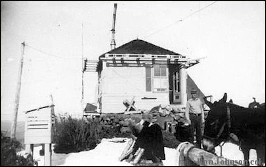
The summit of the mountain holds a quiet history of forest management. The site was once a critical point for fire detection in Lane County. According to firetower.org, the history of the lookout site began in 1912 when a camp was first established to monitor the surrounding wilderness.
As the need for more permanent structures grew, the U.S. Forest Service upgraded the site. In 1921, a D-6 cupola cabin was constructed to provide a better vantage point for lookouts. By 1939, this was replaced by an L-4 cab, which served as the primary observation post for several decades. However, as technology evolved and aerial surveillance became more common, the structure was eventually removed in 1968. Today, the site is registered as US 806 and OR 213, having been formally registered on December 19, 2010, thanks to a nomination by Ray Kresek.
What to Expect at the Summit
One of the most important things to know before tackling the Hardesty Mountain Trail is that the summit does not offer a sweeping panoramic vista. The peak reaches an elevation of 4,273 feet, but because the trees have grown back over the decades since the lookout was removed, the view is largely obscured by the forest canopy.
While some hikers may find the lack of a vista disappointing, there is a unique satisfaction in reaching the peak. The achievement comes from the climb itself and the knowledge that you are standing at a historic site where lookouts once scanned the horizon for smoke to protect the Willamette Valley.
Seasonal Tips for Lane County Hiking
Timing is everything when planning a visit. During the peak of summer, the shade of the old-growth forest provides a welcome refuge from the heat. In the spring, the trail can be muddy and slippery, requiring sturdy boots with good traction. Winter hikes are possible but may require snowshoes depending on the year’s snowfall in the Cascades.
If you visit during the autumn, the ruggedness of this hike can be balanced with a more relaxing activity. Many locals pair their mountain adventures with a Fall Color Drive on the McKenzie River Highway to see the changing leaves along the water. This provides a gentle way to recover your legs after the grueling climb of the Hardesty Mountain Trail.
Plan Your Visit to Hardesty Mountain
Before you head out, ensure you have a physical map or a downloaded offline version of the trail, as cell service is unreliable once you enter the Willamette National Forest. Parking is available at the trailhead, but it can fill up on weekends. Since there are no reliable water sources along the path, carry at least three liters of water per person.
After completing the Hardesty Mountain Trail, head into the town of Oakridge. It is the perfect spot for post-hike recovery, offering local diners and gear shops that cater to the outdoor community. Always remember to pack out everything you pack in to keep our Lane County forests pristine.
Sources
- Trail data and reviews: All Trails
- Lookout history and registration: firetower.org