
Published November 6, 2026
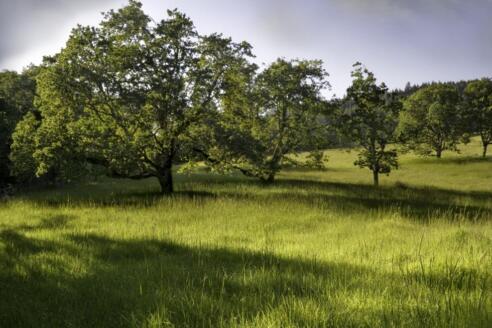
The Coburg Hills are located northeast of Eugene and serve as the beginning of the Cascade foothills, reaching elevations of approximately 2,500 feet. The area is recognized for its remnant grasslands and pine-oak savannas, which provide critical habitat for grassland birds.
Heading northeast from the city center, the landscape begins to shift from the flat valley floor into a series of rolling uplands. These ridges serve as a natural gateway, marking the point where the Willamette Valley meets the first gentle rises of the Cascade foothills. It is a region of subtle beauty, characterized by wide vistas and the distinct scent of native oaks and grasses.
Exploring the Coburg Hills
For those interested in Coburg Hills hiking, the area provides a distinct contrast to the dense forests found further east. Rising to approximately 2,500 feet above sea level, these hills are not as imposing as the high peaks of the Cascades, but they offer a unique ecological perspective. The terrain acts as a transition zone, blending the characteristics of the valley with the ruggedness of the mountains.
Walking through this landscape allows visitors to see the remnant fingerprints of the original Oregon prairie. While much of the valley has been converted for agriculture, the higher ridges of the Coburg Hills have preserved pockets of native vegetation that are increasingly rare in Lane County.
Trail Summary and Quick Reference
Because much of this region consists of conservation areas and private land, the experience is different from a managed city park. Visitors should be prepared for a more rustic environment.
- Trailhead: [needs verification] Specific official trailhead names for Rising Butte are not available in public research.
- Estimated Difficulty: Moderate, depending on the specific ridge accessed.
- Surface: Mixed savanna, woodland, and grassland.
- Best Season: July through August for the driest conditions.
- Amenities: Limited to none; bring all necessary supplies.
Access and Navigation for Coburg Hills Hiking
To reach the area, travel northeast of Eugene toward the community of Coburg. The primary focus for conservation and exploration is the Coburg Ridge area, which extends northward toward Indian Head. This region encompasses roughly 52 square miles of ridgelines and associated lowlands.
Navigation in this part of the county can be tricky due to the mix of private property and conservation zones. We recommend that all visitors check Lane County Road Maps to identify current road closures or access restrictions before heading out. We must explicitly state that specific trailhead names and official mileage for Rising Butte are not available in the provided research, so relying on current topographic maps and local road guides is essential for safe access.
Terrain and Elevation Profile
The elevation profile of the Coburg Hills is characterized by rolling climbs rather than sheer ascents. Starting from the valley floor, hikers move upward toward ridgelines that peak around 2,500 feet. This is a moderate climb that provides a sense of altitude without requiring technical gear.
It is interesting to compare this to the geography on the opposite side of the city. The Coast Range, which begins about 10 miles west of Eugene, also rises between 1,500 and 2,500 feet, but the Coburg Hills feel different because they are the literal doorstep to the Cascades. The slopes here are often more open, providing broader views of the valley below compared to the heavily wooded draws of the Coast Range.
Ecological Highlights: Savannas and Bird Conservation
One of the most significant aspects of this region is its role in wildlife preservation. The lower portions of the hills contain remnant grasslands and pine-oak savannas. According to the Oregon State Wildlife Action Plan, these areas are designated as a Grassland Bird Conservation Area.
These savannas represent some of the best remnant oak habitat on the east side of the Willamette Valley. However, these ecosystems are fragile. A primary goal for local conservation is the removal of invasive conifers and other non-native vegetation that threaten to shade out the native grasses and oaks. By maintaining these open spaces, conservationists protect the nesting sites of grassland birds that cannot survive in dense forests.
Additionally, the valley floor within the Coburg Ridge area includes critical wetland habitats. For example, a 600-acre property was enrolled in the Wetlands Reserve Program in 2005 to help restore riparian zones and protect water quality in the foothills.
Seasonal Planning and Weather
Timing is everything when planning a trip to the Coburg Hills. The weather in Lane County is famously polarized between the wet and dry seasons. Nearly 90 percent of the annual rainfall in the Eugene area occurs between early October and mid-May. During these months, the trails and grasslands can become extremely muddy and slippery, and some low-lying areas may be impassable.
In contrast, July and August are the prime windows for visiting. Only about 2 percent of the annual rain falls during these two months, making it the safest time to navigate the rolling terrain without worrying about washouts or deep mud. It is worth noting that while the city of Eugene receives 50 to 70 inches of rain annually, the nearby Cascade range receives more than 90 inches, meaning the weather can shift rapidly as you climb higher into the hills.
Practical Tips for Visitors
Since the Coburg Hills lack the developed infrastructure of larger parks, self-sufficiency is key. There are no water stations or restrooms once you leave the main roads. Carry more water than you think you need, especially during the dry summer months when the exposed savannas can be quite hot.
If you bring a dog, please keep them leashed and be mindful of the conservation status of the area. Because this is a Grassland Bird Conservation Area, disturbing nesting sites can have a significant impact on local wildlife. Respecting boundaries and staying on established paths helps protect the remnant oak habitats.
For those who typically rely on public transit to get around the valley, keep in mind that the hills are far beyond the reach of standard bus lines. If you are coordinating a ride or using transit to reach a jump-off point in the city, be sure to check the latest LTD service changes to ensure your commute is seamless, especially during the transition to fall schedules.
Nearby Pairings and Post-Hike Stops
If you find that the short climb of the Coburg Hills leaves you wanting more, there are several other local treks in Lane County that offer a different perspective. For a more secluded experience with panoramic vistas, the Olallie Mountain Trail is an excellent choice for those willing to travel further into the wilderness.
After a morning of exploring the ridges, head toward the nearby towns for a meal. Whether you are stopping in Coburg or venturing slightly further toward Cottage Grove, the local dining scene is a great way to wind down. For those heading south, the historic charm of the downtown commercial district in Cottage Grove offers several spots to refuel after a day in the outdoors.
Frequently Asked Questions
Where are the Coburg Hills located?
The Coburg Hills lie east and northeast of Eugene, Oregon, and form the beginning of the Cascades foothills.
What makes the Coburg Hills ecologically significant?
The lower portions contain remnant grasslands, pine-oak savanna, and woodlands that are designated as a Grassland Bird Conservation Area.
What is the maximum elevation of the Coburg Hills?
The hills rise to approximately 2,500 feet above sea level.
When is the best time to visit based on rainfall?
Most rainfall occurs between early October and mid-May, while July and August are the driest months, receiving only about 2 percent of annual rain.
Sources
For more information, see: