
Published October 30, 2026
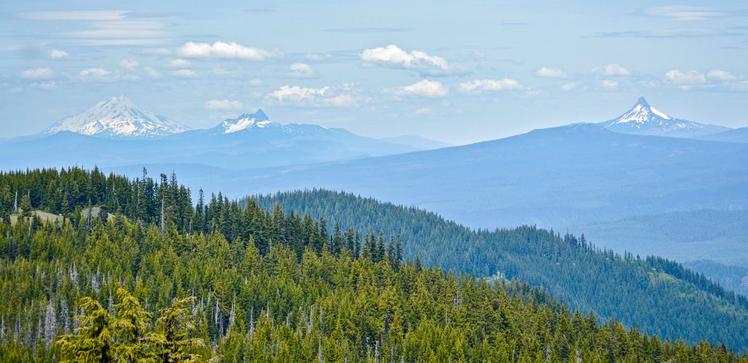
The Olallie Mountain Trail #4100 provided a steep ascent through mixed conifer forests and open meadows to the summit of Olallie Mountain. Hikers enjoyed panoramic views of the Three Sisters and other Cascade peaks after accessing the trail via the Pat Saddle Trailhead.
High above the McKenzie River corridor, the air thins and the canopy opens to reveal the jagged skyline of the High Cascades. This route offered a rewarding escape into the Three Sisters Wilderness, blending the solitude of deep forest with the exposure of a high ridge. For those who visited during the 2026 season, the journey was as much about the steady effort of the climb as it was about the final vista.
The Olallie Mountain Trail provided a classic Oregon wilderness experience, characterized by a transition from dense greenery to sweeping alpine views. Located near Blue River, it served as a quiet alternative to the more crowded peaks of the Central Cascades.
A Retrospective of the Olallie Mountain Trail
The atmosphere of the hike was defined by its isolation. Because it sits within the Three Sisters Wilderness, the trail maintained a raw, undeveloped feel. Hikers moved through a landscape that felt timeless, where the only sounds were the wind through the pines and the occasional call of a mountain bird. The signature feel of the ridge hike was one of gradual revelation; as the elevation increased, the dense forest began to break, teasing glimpses of the surrounding peaks before the full panorama opened up at the summit.
The route was particularly striking during the late summer and early fall of 2026, when the hillside meadows shifted colors and the visibility across the Cascade Range was at its peak. It was a place where the scale of the wilderness became apparent, placing the hiker in a vast expanse of volcanic peaks and ancient forests.
Trailhead Access and Route Logistics
Getting to the start of the climb required a bit of patience and a drive into the heart of the Willamette National Forest. The journey began at the Pat Saddle Trailhead. From there, the route did not immediately turn upward; instead, hikers followed Olallie Trail #3529 south for approximately 2 miles. This initial stretch served as a gentle warm-up, winding through the lower elevations and setting the stage for the more demanding ascent to follow.
The transition occurred exactly where Olallie Trail #3529 entered the Three Sisters Wilderness. At this junction, the path shifted, and the Olallie Mountain Trail #4100 branched off, signaling the start of the true climb. For those coordinating their trip, checking Lane County Road Maps: How to Find Closures was a practical step, as forest roads in the Blue River area can be subject to seasonal closures or maintenance updates.
The Climb: Terrain and Elevation
Once the trail turned southwest, the physical demands increased significantly. The climb was steep and relentless, requiring a steady pace and a fair amount of endurance. The terrain began in mixed conifer forests, where the shade of towering pines and firs provided some relief from the sun. The ground was often a mix of soft needles and rocky outcrops, typical of the volcanic soil found in this region of Lane County.
As the elevation gained, the forest began to thin. The dense canopy gave way to open hillside meadows, where the environment shifted from enclosed woodland to an exposed alpine setting. This transition was one of the highlights of the ascent, as the widening horizons allowed hikers to orient themselves against the distant peaks. The climb tested the legs, but the shift in scenery provided a mental boost, moving from the emerald greens of the forest to the golden hues of the high-altitude grasses.
Summit Views and the Lost Lookout
Reaching the top of Olallie Mountain was the ultimate reward. The summit offered panoramic views that captured the grandeur of the Three Sisters and several other prominent Cascade peaks. On clear days, the horizon seemed to stretch forever, showcasing the dramatic contrast between the deep valleys of the McKenzie region and the snow-capped summits of the wilderness.
For those looking for a historical landmark, the summit told a story of loss. The old Olallie Mountain Fire Lookout, which once served as a vital eye for forest rangers, was no longer standing. The structure burned down in the fall of 2019. While the building was gone, the site remained a point of interest, reminding visitors of the constant battle against wildfire in the Oregon backcountry. The absence of the tower actually enhanced the feeling of solitude, leaving the summit as a wide-open platform for taking in the views.
Practical Requirements for the Olallie Mountain Trail
Accessing this area required adherence to specific Forest Service regulations. A wilderness self-issue permit was required for all visitors. These permits are essential for tracking wilderness use and ensuring that the land is managed sustainably. For those bringing horses, strict weed-free feed restrictions were in place to prevent the introduction of invasive species into the fragile alpine ecosystem.
One critical detail for anyone planning a trip to this area was the need for direct communication with officials. We could not verify current trail conditions from public sources, as the official Forest Service page did not list real-time updates. Consequently, visitors were directed to contact the local ranger station for verification of trail blockages, snow levels, or fallen trees before heading out.
Wilderness Etiquette and Recreation
The Three Sisters Wilderness is managed to preserve its natural character, and the activities permitted on the Olallie Mountain Trail reflected this. Hiking, horse riding, and camping were the primary ways people experienced the land. Whether it was a quick day hike to the summit or a multi-day backpacking trip, the expectation was a Leave No Trace approach.
Backpackers found the area ideal for overnight stays, though the lack of developed campsites meant that primitive camping skills were necessary. Horse riders shared the trail, and the etiquette of the wilderness required a respectful coexistence between hikers and equestrian groups. Following these regulations ensured that the ridge remained a quiet sanctuary for both humans and wildlife.
Nearby Lane County Pairings
A trip to the Blue River area often served as part of a larger exploration of Lane County’s outdoor offerings. For those who enjoyed the steady climb and panoramic reward of Olallie Mountain, the Mount June Trail: A Quiet Hillside Walk in Cottage Grove offered a similar sense of peace and elevation, albeit in a different part of the county. Combining these two hikes provided a great contrast between the rugged wilderness of the Cascades and the softer hillside ruins of the Umpqua region.
After a long day on the trails, many visitors returned to the local communities for a meal. While the wilderness provides the silence, the towns of Blue River and beyond provide the warmth of local hospitality. For those returning to the Eugene or Springfield areas, it was always wise to check for any LTD Service Changes: Fall 2026 Schedule Updates if they relied on transit for their final leg home, ensuring a smooth transition from the wild ridges back to the city.
Frequently Asked Questions
How was the Olallie Mountain Trail accessed?
The trail was accessed from the Pat Saddle Trailhead by following Olallie Trail #3529 south for 2 miles.
What permits were required for this hike?
A wilderness self-issue permit was required for those using Olallie Mountain Trail #4100.
What happened to the Olallie Mountain Fire Lookout?
The old Olallie Mountain Fire Lookout burned down in the fall of 2019.
What types of recreation were allowed on the trail?
The Forest Service identified hiking, horse riding, and camping as permitted recreation opportunities.
Sources
For more information, see: