
Published September 6, 2026
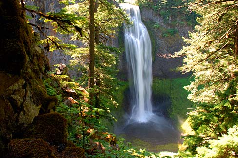
Salt Creek Falls Overlook is a short trail in the Willamette National Forest featuring a 286-foot single-drop waterfall. Located off Highway 58, it provides paved clifftop viewing platforms and access to the longer Diamond Creek Falls Loop Trail.
Salt Creek Falls Overlook: — Oakridge, Oregon
The Salt Creek Falls Overlook: provides one of the most dramatic and accessible vistas in the Willamette National Forest. For those traveling along the Willamette Pass Highway, it serves as a perfect stretch-your-legs stop that delivers a massive visual reward for very little effort. The sight of a massive column of water plunging nearly 300 feet into a rocky canyon creates a sense of scale and power that is hard to miss, even from the clifftop viewing platform.
Visiting the Salt Creek Falls Overlook
Standing at 286 feet, Salt Creek Falls is recognized as Oregon’s second tallest single-drop waterfall, surpassed only by Multnomah Falls. The signature feel of the Salt Creek Falls Overlook: is one of immediate impact; you move from the noise of the highway to a serene, high-altitude vantage point where the roar of the falls dominates the environment. It is an ideal spot for photographers and families who want to experience a major Cascade waterfall without committing to a multi-hour trek.
For those planning a visit, here is a quick-reference summary of the observation site:
- Trailhead: Salt Creek Falls Observation Site, Highway 58
- Length: Approximately 50 to 250 yards (depending on loop)
- Elevation Gain: Minimal/Flat to the overlook
- Difficulty: Easy
- Surface: Paved and maintained paths
- Best Season: Spring into Fall
- Amenities: Interpretive exhibits, picnic area, viewing platform
Access and Driving Directions to the Overlook
The Salt Creek Falls Overlook: is managed by the US Forest Service within the Middle Fork Ranger District of the Willamette National Forest. Because it is located directly off a major artery, it is one of the easiest high-impact nature stops in Lane County.
To reach the site, travel along Highway 58. The observation site is located approximately 23 miles southeast of Oakridge and about 5 miles west of Willamette Pass. Look for the well-marked signage for the Salt Creek Falls Observation Site. While the site is easily accessible via the highway, we could not verify specific current parking capacity or real-time congestion data from public sources, so expect busier crowds during peak summer weekends.
Trail Surface and Terrain at Salt Creek Falls Overlook
The terrain at the Salt Creek Falls Overlook: is designed for accessibility. Upon parking, visitors are greeted by interpretive exhibits that provide context about the geology and ecology of the region. From these exhibits, the walk to the primary viewing platform is approximately 50 yards.
The surface is well-maintained, making it a breeze for most visitors. If you have a few extra minutes, there are loop options that take you through the picnic area, extending the walk to about 250 yards before returning to the parking lot. This small loop allows you to see the surrounding forest canopy and the layout of the canyon rim before heading back to your vehicle.
Scenic Highlights and Wildlife
The primary draw of the Salt Creek Falls Overlook: is the sheer verticality of the 286-foot drop. The water crashes down with significant force, creating a mist that often supports lush greenery along the canyon walls. Beyond the waterfall itself, the site is a haven for specific avian species. Visitors visiting in July may spot black swifts, which hatch during this month and are known for their agility in the air around the canyon.
This quick stop offers a different experience than the longer, more immersive treks found elsewhere in the region. For example, if you are looking for a deeper dive into old-growth forests and a more secluded atmosphere, the Proxy Falls Loop provides a contrasting experience with its winding paths and ancient Douglas-firs. While the Salt Creek Falls Overlook: is about the “big view,” Proxy Falls is about the journey through the woods.
Practical Tips for Your Visit
Before you head out to the Salt Creek Falls Overlook:, there are a few logistical details to keep in mind to ensure a smooth trip. First, a valid Recreation Pass is required for parking at the Salt Creek Falls Observation Site. Be sure to have your pass displayed on your dashboard to avoid citations.
Water is not available at the site. Whether you are just doing the short walk to the platform or extending your trip to the longer loops, you must bring your own drinking water. The recommended hiking season runs from spring into fall. During the winter, snow can make the highway access more challenging, though the site remains a popular destination for those with appropriate gear.
Expanding Your Trip: Diamond Creek Falls Loop
For those who find the Salt Creek Falls Overlook: too brief, there is an excellent way to extend the adventure. From the picnic area, a bridge crosses Salt Creek, serving as the gateway to the Diamond Creek Falls Loop Trail.
This is a 3.2-mile loop that offers a more traditional hiking experience. The trail skirts the rims of both the Salt Creek and Diamond Creek Canyons, providing multiple vantage points of the rugged terrain. It is a great option for those who want to transition from a quick tourist stop to a legitimate nature hike without leaving the immediate area. The loop provides a sense of the vastness of the Middle Fork Ranger District and the deep carvings made by the region’s waterways over millennia.
Nearby Pairings and Local Stops
A stop at the Salt Creek Falls Overlook: is often part of a larger exploration of the Cascades. If you are visiting during the colder months, you might pair this with other winter hiking and hot springs spots in Lane County to balance the chilly air with some natural warmth.
For those returning to the valley, remember to check your transit options. If you are utilizing public transportation for any part of your journey, you can find the latest LTD Fall 2026 schedule updates to ensure your commute back to Eugene or Springfield is seamless. Whether you are heading back for a meal at a local favorite or returning home, planning around the seasonal transit changes helps avoid unnecessary delays.
The Salt Creek Falls Overlook: remains one of the most efficient ways to witness the raw power of Oregon’s water features. Its combination of accessibility and scale makes it a mandatory stop for anyone traversing Highway 58.
Frequently Asked Questions
How tall is Salt Creek Falls?
The waterfall is 286 feet tall and is recognized as Oregon’s second tallest single-drop waterfall after Multnomah Falls.
Is a permit required to visit the overlook?
Yes, a valid Recreation Pass is required at the Salt Creek Falls Observation Site.
Where is the Salt Creek Falls Overlook located?
It is located in the Middle Fork Ranger District of Willamette National Forest, approximately 23 miles southeast of Oakridge and 5 miles west of Willamette Pass along Highway 58.
Is there water available at the trailhead?
No, water is not available at the site, so visitors should bring their own supply.
Sources
For more information, see:
Image credits
- Featured: Photo by Gary Halvorson, Oregon State Archives (ATTRIBUTION) via Wikimedia Commons.